What is the physical geography of Svalbard like?
What glacial features can be recognised?
What is the physical geography of Svalbard like?
The cold climate gives Svalbard a distinct physical landscape and processes. Rock, ice and sea are the main landscape features. There is no tall vegetation and only lichen above 1100m. Svalbard is glaciated, 60% of the land is ice covered, and it has small valley glaciers as well as large outlet glaciers draining ice-caps. Glaciers and the rivers issuing from them erode the landscape and then transport and deposit the eroded materials. Weathering and erosion are mainly the mechanical processes of frost shatter, freeze-thaw, abrasion and plucking.
Ground is permanently frozen and impermeable nearly everywhere above 100m altitude. This is called permafrost and varies from 10m to 45m thickness. Only the very top layer thaws in summer enabling some plant growth. It causes problems for constructing and heating buildings and explains why some buildings and pipes are on short stilts.
What glacial features can be recognised?
Glacial landforms include include fjords, glacial valleys, arêtes and nunataks (erosional), outwash plains, alluvial fans, moraines and braided streams (depositional). Svalbard also has periglacial features associated with cold areas, such as pingos which are small hills created by ice lenses underground, and patterned ground resulting from frost and ice heaving materials up from the ground.
Links
This image is of the Northern Lights.
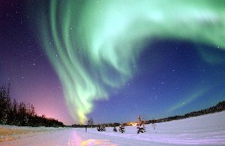
Northern lights
Watch the video clip of the Northern Lights from YouTube.
Can you guess what might cause this light show in the night sky?
Cause of the Northern Lights
Particles from the Sun (smaller than an atom) are captured in the Earth's magnetic field (the same field that makes compass needles point to the north). The captured energy causes the gases of the atmosphere to become excited and this causes the emission of light with different colours.
Svalbard becomes the fantastic setting for much of the drama in the children's book Northern Lights (you may have already read it) , the film of which is called The Golden Compass.
Armoured (polar) bears roam the extreme Arctic landscape and its remoteness provides the perfect location for the prison of Lord Asriel. Lyra, the main character, crash lands in Svalbard, is captured by the armoured bears and taken to Lord Asriel's prison. The Northern Lights can be seen flickering in the sky.
Having read excerpts from final chapter of the Northern Lights or seeing the film (released 7 December 2007) use Google Earth to identify some suggested locations for the film version of the Northern Lights. You can identify these by creating Google Earth placemarks. See how to do this at Juicy Geography.
Google Earth placemarks
Look at the list of physical features to identify. Use this glossary to help you. Can you highlight these using different coloured placemarks?
Using markers to identify features
Working in small groups, choose one glacial feature to research and describe in further detail. Add your extra information can be to the placemark. See how to add further information to your placemark.
Send your finished placemarks to a shared folder so you can assess each other work at the end.